Due to individual interpretation and differences, it is virtually impossible to place one meaning on symbols used in the Rock Art of the Anasazi. One has only to look at the example of Kokopelli to realise the varying 'meanings' attributed to this one figure.
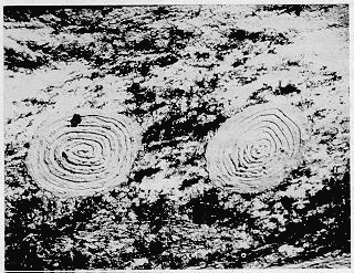
Another example is that of the spiral. Spirals pecked into the rock surface at Chaco Sun Dagger site were reportedly used as a solar observatory. By taking note of the position of the sun on the spirals, the Anasazi were able to mark the summer solstice, the autumn equinox and the winter solstice. (Ferguson & Rohn 1987 p62) However, spiral or coil can also be a symbol of the wind, snake, wave or spring. (Patterson-Rudolph 1990, p117) |
 |
Therefore, I will not define what each symbol supposedly means. Instead, a hypothesis for the purpose of Early Anasazi Rock is presented.
Basketmaker Spatial Identity: Rock Art as Culture and Praxis.
William D. Hyder
(c) 1994
Rock art serves many purposes, primary among them is the delineation of a people's cultural identity. Both individual and cultural identity includes a spatial element based on spatial memories, imagery, and activities (Fried 1963:156), and many nonliterate societies used rock art to define their territory and their spatial identity. I propose that Basketmaker people in the American Southwest recognized agricultural plots and gathering areas as belonging to specific family groups and that the resulting spatial organization was identified by easily visible, distinctive rock art panels. Furthermore, I suggest that the content of the art may indicate that the ownership was identified with the couple or family unit as opposed to solely the male or female lineage as is more common in later Pueblo cultures.
Territory and Boundaries |
 |
Human self-identity and social identity manifests itself in some form of territoriality expressed through human behaviors such as the definition, marking, communication, and regulation of territory. As a human construct, territory is defined by natural or cultural boundaries and markings (Malmberg 1980:7-8). Mountain peaks, ridges, and other prominent features typically are recognized as boundaries delineating both personal and cultural space. Altman (1975:107) defines territorial behavior as "a self/other boundary regulation mechanism that involves personalization of or marking of a place or object and communication that it is `owned' by a person or group." People orient and define themselves in relation to these boundaries, and boundaries define a group's range, i.e. where they hunt and gather food, raise families, find mates, and conduct their rituals.
Prominent geological features are typically recognized as boundaries and these often become elements in a people's cosmology. The Zuni, for example, recognize the Sandia Mountains, Mount Taylor, Sierra Abajo, the San Francisco Peaks, and the Mogollon Mountains as sacred places (Ferguson and Hart 1985:51). These sacred mountains are important to the definition of Zuni identity, but they are distant enough from Zuni, the Middle Place, that we would not expect them to be defended either directly or indirectly (although modern political realities now intervene and require new behaviors). Thus, they were "marked" in creation stories, myths, legends, and rituals. These markings are not readily visible to people outside the culture, nor do they need to be visible to have meaning to the Zuni.
Closer to home, at the boundaries of the economically important space, we encounter a physical form of marking. Depending on the degree of defense and the size of the territory, boundary marks may range from signs delineating imaginary lines and access rights to defensive structures such as forts and walls. To be meaningful, these signs must be recognized by neighboring groups. Lee and Hyder (1991), for example, propose that stylistic similarities in the rock art found at sites near ethnographically documented boundaries between neighboring tribal groups in south-central California are one indicator of cultural interaction. Each tribe maintained its own stylistic identity to define its own space, yet they shared a degree of stylistic similarity to reinforce their social interactions. The overlap in styles was not accidental; it was a deliberate product of cultural interaction to encourage and insure reciprocal access to neighboring territory.
Darrell Lewis (1988) cites another example wherein the areal distribution of Arnhem Land rock art styles reveals something of the areal distribution of cultures and the degree to which territorial boundaries were open or closed. Based on studies of Australian Aboriginal socio-economic strategies, Lewis (1988:82) hypothesizes that reciprocity requires emphasizing similarities among groups where the environment is unpredictable and that social differences will be emphasized where resources are abundant and reliable. He goes on to propose that the widespread distribution of one of the earliest rock art styles in northern Australia coincides with a particularly poor climatic cycle, and that stylistic similarity in the rock art functioned to maintain large territories with reciprocal access rights for neighboring groups. Later styles became more distinctive and areally circumscribed as climatic conditions improved. In other words, the similarity in early art styles served to reinforce cultural similarities, as opposed to local group identities.
As one moves closer to primary territory, personal space, or "the middle place," the functions of marking change. Marks at the edges of territory serve to define and secure space; marks at the center are more personal and perhaps more inviolate. They serve to link the inhabitants to their physical and cultural space. Much of what we study in our effort to define rock art styles are sites at edges of territories. Much of what we study to define functional uses of rock art are sites associated with centers. It is not uncommon to encounter situations where sites from two adjacent cultures exhibit a higher similarity than that between any two sites within a single culture area. In the first instance, a high degree of similarity may be necessary for the message to be recognized. Nearer the center, people are freer to engage in a wider range of behaviors, and different functional sites may contain very different, more personal forms of rock art. While the range of possible themes for such sites might vary from archaeoastronomy to fertility to shamanism, the sites still serve to define the people's spatial identity. As Young (1988:238) observes, "The mere presence of carvings and paintings on the rocks heightens the sense of place for the Zunis; it reinforces their perception of themselves as a people intimately linked to their particular landscape."
Defense of territory is deliberately excluded from the definition used here. The degree of defense can vary widely from culture to culture and from time to time. For example, Steward (1970:119-120) argues that mobile groups (i.e. typical hunter-gatherer bands) have no need to defend territory until such time that agriculture ties them to fixed places on the landscape. In practice, some form of passive defense or boundary maintenance exists in all communities and their level of corporate development and sedentism determines, in part, the intensity of defensive behavior (Peterson 1978:24-25). Hunters and gatherers are more likely to rely on markings and displays to identify territory than they are to rely on physical defense (Jochim 1981:169). Mobile groups are often too small and their range too large for them to physically defend their territory anyway. One's success in life depends on an intimate knowledge of the local environment, limits to the land's carrying capacity, and alternatives in the event of localized failures of favored resources. If an interloper unfamiliar with the territory does enter, physical defense may not even be needed.
In summary, cultural identity includes a spatial identity that helps legitimize socio-cultural norms. Maintaining and defending that territory includes marking space, and a common practice among preliterate peoples was to produce rock art.
 |
The Basketmaker People |
Seasonal agricultural strategies involved first planting the mesa top fields and then moving a few days later to the canyon bottoms. It seems probable that canyon bottom agricultural fields were a hedge against late frosts and the greater uncertainty of mesa-top, dry-land farming. Canyon bottom agricultural activities coincided with the early ripening and harvesting of native plants and the later harvesting of agricultural crops coincided with the maturation of other natural plants. Dried corn and other plants were stored in the floors of pithouses on the mesa and in storage caves in the canyons. The low investment in storage facilities and the lack of recognizable habitation sites near canyon storage structures would seem to indicate that the canyon bottom crops were a hedge against climatic failures. The periodic use of these sites creates a need for identifying one's space; possibly with rock art in the absence of other identifying features such as permanent structures, dwellings, or a prolonged, regular presence at the site.
If Matson (1991) and Lipe's (1993) summaries are correct, then we can picture loose-knit bands of Basketmaker extended families gathered into rudimentary villages during the period covered in this paper. No clear political or economic leadership had yet emerged, and it appears that families were the center of community organization rather than an elite. Within this social structure, families controlled the use of traditional gathering areas and agricultural plots. Although families were mostly autonomous, the need for community interactions for social and physical survival required a degree of inter-family communication and signaling. Thus, the passive marking of one's territory would serve to identify family agricultural plots and to reaffirm one's traditional ties to the land.
Some of this text downloaded from http://zzyx.ucsc.edu/Comp/Bill/CandP.html

Back to Rock Art