Plans of Piazza del Popolo
Given that plans are not necessarily always to be taken literally
- artistic licence and imagination can sometimes play a part -
what can we learn from illustrations of the area from the
15th century onwards about the appearance of Piazza del Popolo
before it reached its definitive (so far) form under Valadier in the
early 19th century?
We shall see that, if no one plan superficially appears accurate, it
may nevertheless be possible to collate several to achieve a more
truthful result - that is, if we allow for one plan being in part copied
from another.
 |
BIG
|
STROZZI Alessandro drawing
1474
25.JPG | |
Alessandro Strozzis drawing of 1474 shows the area as a large blank
to the top of the church and the adjacent walls. There is a square-based
ruin, presumably a tomb, nearby; but should we trust it when the Maosoleum
of Augustus (Mauseolus Divi Augusti) is shown with a square base and arches?
Behind the church, on the Pincio, are various tall arched ruins, but it is
impossible to locate them closely to our piazza - they could be intended to
be as far away as Villa Medici.
 |
BIG
|
SCHEDEL Hartmann
1493
26.JPG | |
Hartmann Schedel in 1493 shows SM del Popolo with a central dome (!); he also
shows ruins on the Pincio but, once again, it is impossible to gauge their exact location.
 |
BIG
|
FAUNO Lucio
1548
1.JPG | |
Lucio Fauno in 1548 is rough and abbreviated, although he does sketch
the Msueoleum of Augustus with something near accuracy - but his representation
shows only the main c monuments, and the hills - not Renaissance buildings
nor yet ancient ruins.
 |
BIG
|
BUFALINI Leonardo
1551
31.JPG | |
Leonardo Buffalini in 1551 is more helpful. Directly adjacent to the church he labels
Hic fuit sepulcru. Neronis. And he shows a circular monument (surely a tomb - for
similar ones have survived in the vicinity) outside the Porta Flaminia, on the Via
Flaminia, river side This whole area outside the walls is now given over to "vinea"
- EXPLAIN.
 |
BIG
|
LIGORIO Pirro
1552
32.JPG | |
Things begin to look up considerably when we come to Pirro Ligorios plan of the
following year, 1552 - as different from Bufalini as chalk from cheese. But is it any
more accurate? The Mausoleum of Augustus looks good (with an added, seated colossal
statue!), and the Arco di Portogallo on the Corso (knocked down in WHEN because it
blocked traffic) is also shown. SM del Popolos facade is shown in abbreviated fashion,
but the Pincio has only the work NAVMACHIAE on it, and nothing illustrated.
 |
BIG
|
PINARD Hugo
1555
33.JPG | |
Hugo Pinard in 1555 is useful for underlining just how rural the area was outside
the walls: villas, trees and fields dot the hills. We can recognise the narrow lane
leading up to the Villa Giulia and, further along on bthe same side, Sangallos
little church with the its dome. Much has changed since, especially the carving out
of the Via dei Belle Arti to make a whole valley - the Valle Giulia - between
these two monuments.
 |
BIG
|
BEATRIZET Niccolo
1557
34.JPG | |
NiccoloBeatrizet in 1557 makes things easy by not including our church
or piazza at all; while Giovanni Dosio
 |
BIG
|
DOSIO Giovanni A
1561
35.JPG | |
in 1561 shows the church, the trident of streets,
and the rural life of the vigne outside tghe walls.
 |
BIG
|
PANVINIO Onofrio
1565
5.JPG | |
Onofrio Panvinio in 1565, concerned only with the ancient monuments, shows a
naumachia (see above) by the Pincio, sketches in the trident as dotted lines,
and places the tomb of Nero up on the Pincio
 |
BIG
|
CAMOCIO Giovanni
1569
36.JPG | |
Giovanni Camoccio in 1569 also shows the villas and farms outside the walls,
and the trident within it; but according to him there is a wall turning the
piazza into a small triangular area, with another gate in it into the city
 |
BIG
|
DUPERAC Estienne
1574
6.JPG | |
Etienne du Peracs reconstructionn of ancient Rome, of 1574, lets imagination run
riot. There are no ruins, only complete monuments, put together with an eye
for splendourwhich makes one wonder whether he is any relation to Piranesi...
His taste for square tombs with pyramids on top - there are three visible in this
detail - helps give a context to the Chigi Chapel, without necessarily convincing
us that there were several such tombs near our church Mario Cartaro 8.JPG in
1579 has different but equally impressive pyramidal monuments.
 |
BIG
|
BRAUN & HOGENBERG
1575
37.JPG | |
Braun and Hogenberg in 1575 have the same triangular space by the church as
Camoccio, so either such a wall was there, or they copied his work.
 |
BIG
|
CARTARO Mario
1575
39.JPG | |
Mario Cartaro, also 1575, has no such triangular space, but a fountain instead,
and the trident clearly marked.
 |
BIG
|
DUPERAC Estienne ed. LAFRERY Antonio
1577
40.JPG | |
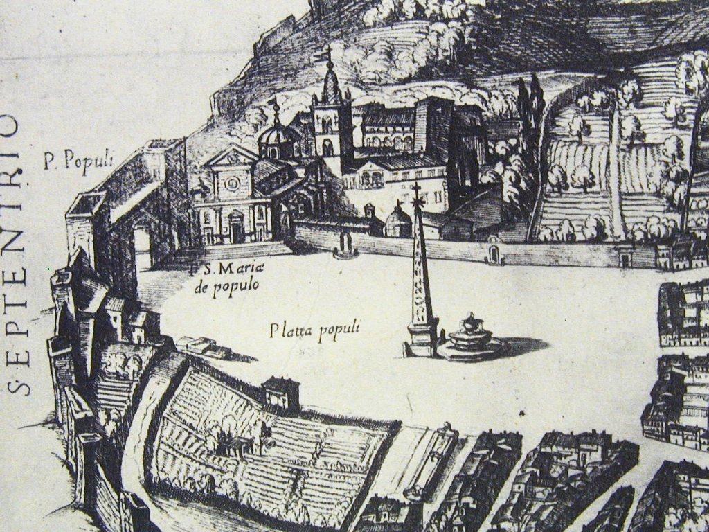
40.JPG: Duperac and Lafrerys work of 1577 has a better view of the fountain, which
is in operation, and has two superimposed basins. The inscription PLATEA POPVLI
suggests the arfea had a formal name by now, and the streets of the trident are also
named..
 |
BIG
|
ANON Salone Sistina Bibl. Vaticana
1588/90
41.JPG | |
The anonymous fresco in the Salone Sistina in the Vatican, of 1588/90, now shows
the obelisk in place, next to the fountain, and a large circular structure, perhaps the
Tomb of Nero, on the hill directly to the east of our church.�@AmbrogioBrambilla, 42.JPG,
shows the same.
 |
BIG
|
TEMPESTA ANTONIO
1593
43.JPG | |
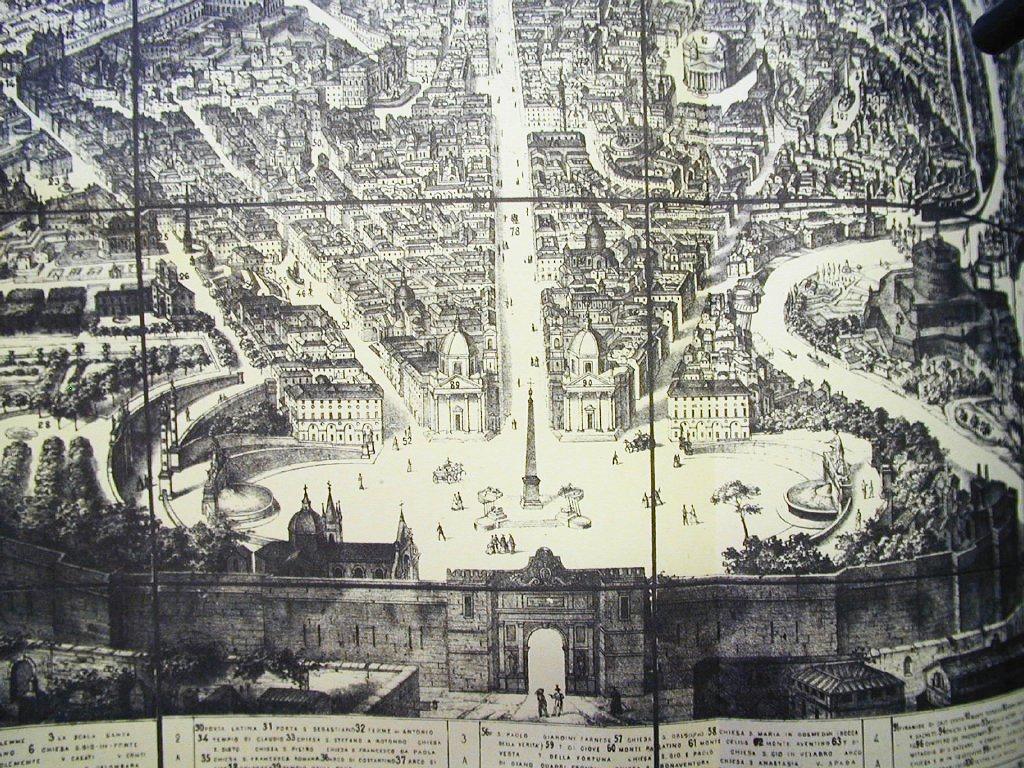
Antonio Tempestas plan of 1593 is of a much higher quality than most of the
material we have seen thus far. He shows the walls of Rome, the Porta del Popolo
with a walkway between the towers - and vegetable gardens where the western
hemicycle of Piazaza del Popolo now stands. Our Piazza currently looks little
different from S Peters (cf. Tempesta 23.JPG), in that both have one obelisk and one
fountain, not to mention a similarly triangular shape. Perhaps any
self-respecting square (such as Piazza Colonna) needed a monument and a fountain
(qalthough at this date Piazza Navona was lacking its obelisk, and Berninis attention
to the fountains was far in the future).
We still find the kitchen gardens - 70.JPG - for the houses and palazzi on the roads
of the trident are backed by long gardens, none too different from those shown for the
Villa Medici - 72.JPG: Vivarium magni ducis Hetruriae - with hills fields and ruins
to the north of the fountain (which is still there - the most beautiful in Rome,
even when in need of repair and levelling) Toward the Tiber, the garden-ends are
banked up and galleried - a reminder of the serious flooding which only became less
of a threat in the 19th century, with embankment work along the whole of the urban
stretch of the river.
 |
BIG
|
GREUTER MATTHEW
1618
44.JPG | |
Matthew Greuter in 1618 also provides good detail, from which it is clear how
irregular the trident ends are, making nothing like the regulation French
patte doie.
 |
BIG
|
MAGGI Giovanni
1625
47.JPG | |
47.JPG Giovanni Maggi in 1625 shows the area becoming more and more pleasant, with
tgrees planted in a line outside the walls, forming a kind of boulevard, and
th4e south side of the piazzaa - next to the named Strada Paolini - provided with
regular terraced houses. One wouldnt think it the same place as that delineated
so scruffily by G. de Rossi 50.JPG in 1637 - which is no doubt why the Rossi-Tempesta
publication of 1661/2 - 51.JPG - was necessary CHECK. This now shows the two
churches in between the forks of the trident, shown also in plan in
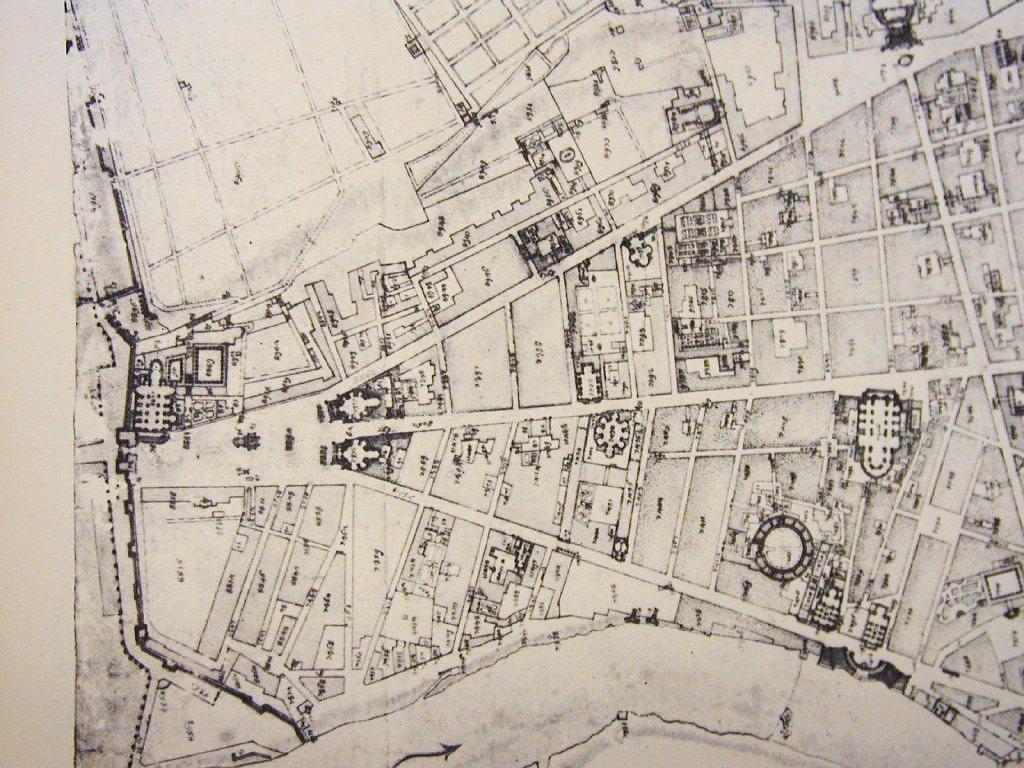
Matteo Gregorio de Rossis publication of 1668, 52.JPG. Now the piazza is beginning to
take on an almost regular triangular shape, spreading out from the Porta del
Popolo.
 |
BIG
|
NOLLI Giovanni B
1736/44
54.JPG | |
We can see this clearly in GB Nolli's meticulous plan of 1736-44 Withy the two
trident churches forming the beginnings of something lively and dynamic, to accompany
the interesting ground plans of various churches visible down the Corso, the
clustered obelisk and fountain look silly: nothing is being made of their potential. Is this
a symptom of lack of funds? Lack of interest by the Papacy? The Papacys attention
diverted elsewhere?
 |
BIG
|
VASI Giuseppe
1781
57.JPG | |
In Giuseppe Vasi's plan of 1781, the area is still not completely urbanised for,
although most of the piazza now has housing faces, there is still the large
garden on the west side. Ripe for development, one might say - and curious
how this key area, and considered as such by Renaissance popes, seems to
have languished somewhat after Bernini and Alexander VII, in favour of other
schemes.
 |
BIG
|
RUGA Pietro
1818
58.JPG | |
Pietro Ruga in 1818 shows these works under way. The west side is still
as it always was, but a hemicycle has been carved out to the east, and its present
disposition is taking shape. In 61.JPG Tommaso Falcettis model of 1826, the
new layout is in place, Tyhe fountain has gone from the centre, but the
hemicycles with their fountains are in place, as are the promenade slopes
of the Pincio, the layout of which is much cleqarer in Alessandro Uggeris
plan 60.JPG of the same date.
How do the renaissance imagining of the classical monuments inside and
outside the walls accord with the reality, in so far as it can be reconstructed?
Giuseppe Luglis view 19.JPG of 1939 sketches in the Ara Pacis and the solarium,
but does not do Piazza del Popolo in detail. Howevedr 20.JPG his 1949 revision
(with Italo Gismondi) shows SEPULCRA marked under each of the two tridentine
churches, and a cippus marked on the E side of Via Flaminia outside the walls Today
there is also a circular mausoleum (still visible near the tennis courts): when was
this discovered? Try Amandas book.


